
Temperatures warm to around 70° Thursday afternoon while the sky remains mostly sunny.
Sunshine returned in abundant supply for many by midday Thursday. By that time, most locations were in the 60s. Temperatures warm to around 70° Thursday afternoon. The sky remains mostly sunny, but the sky might be a bit cloudier in far southeast Alabama. The sky becomes partly cloudy overnight, while temperatures fall to near 50°.
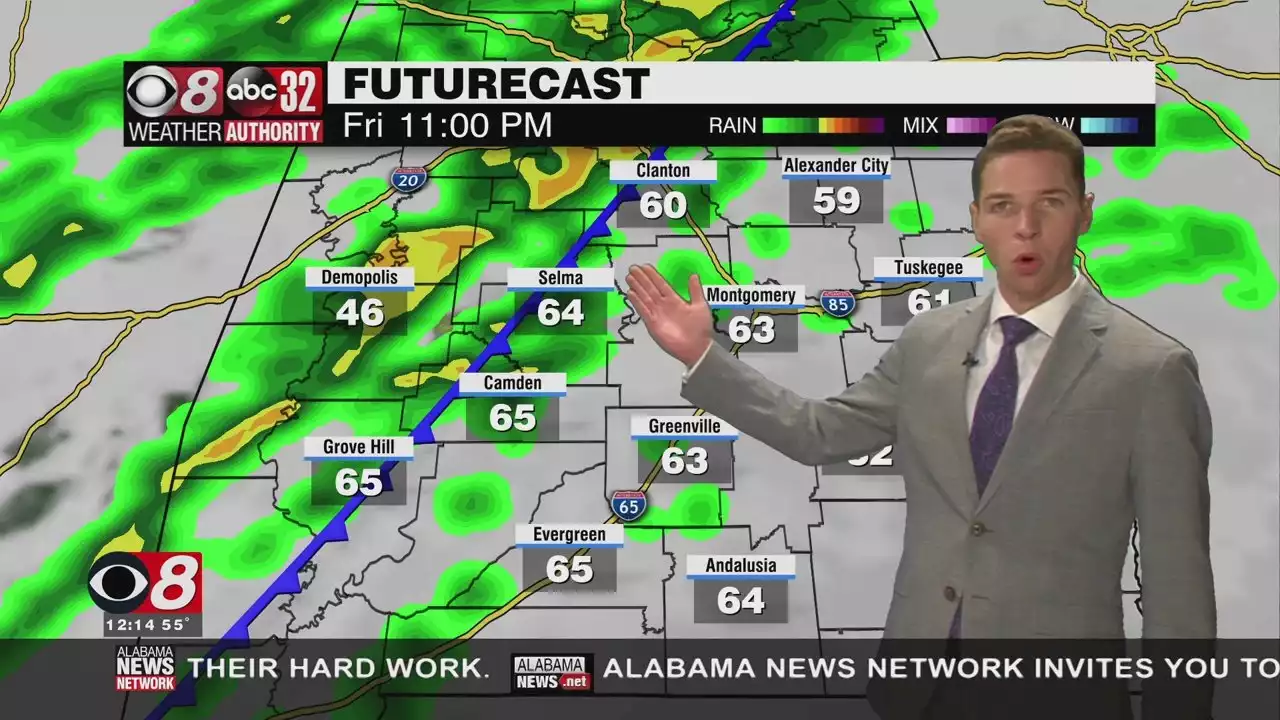
Our weather pattern remains active. That becomes apparent again late Friday. Severe storms appear possible, including a risk for damaging winds, a couple tornadoes, and quarter size hail. The severe risk window may not open until around sunset. During the day, we may merely see a mix of sun and clouds with scattered showers and highs in the 70s.
Storms sweep west to east Friday night. The severe weather window could stay open as late as 3AM for our southeast communities. Storms likely congeal into a line immediately in advance of a cold front with time. The front sweeps through our area too, and delivers a blast of cold air this weekend. Temperatures may not fall below 40° Friday night. However, temperatures may not reach 50° Saturday afternoon, despite the return of sunshine.
A strong northwest wind persists behind the front. Wind chills could be in the 30s all of Saturday. Even Saturday night could be somewhat breezy. With actual air temperatures falling into the 20s, wind chills could be in the teens. Temperatures trend milder Sunday with abundant sunshine. However, it looks like most locations only warm to around 60° during the afternoon. Sunday night lows fall into the 30s.
Temperatures trend warmer next week. However, another disturbance moves through Alabama next Tuesday. Clouds and the chance for rain increase by Monday night. Tuesday features the best chance for rain. However, the disturbance may linger across the southeast through the middle of next week. That could lead to lingering clouds and rain next Wednesday. Our forecast for next Thursday still looks dry for now.
日本 最新ニュース, 日本 見出し
Similar News:他のニュース ソースから収集した、これに似たニュース記事を読むこともできます。
 Cloudy And Cool Wednesday, Some Sunshine Thursday - Alabama NewsThe storms were gone by sunrise. However, the clouds were not. It appears clouds remain overhead for the rest of the day. alwx montgomeryal selma prattville pikeroad wetumpka alabamanewsnetwork
続きを読む »
 Snow possible for parts of Alabama late FridaySnow is possible for parts of Alabama late Friday. alwx
続きを読む »
 N.J. school closings, delayed openings due to snow for Wednesday (03/09/2022)A storm system will likely bring light snow and possible sleet on Wednesday.
続きを読む »
 Tornado Storm Damage Reported in Barbour County - Alabama NewsThe National Weather Service reports storm damage in Barbour County from the storms that passed through Central and South Alabama overnight. alnews alwx stormdamage alabamanewsnetwork
続きを読む »
 D.C.-area forecast: Cool and calm today, but a stormy Saturday lurksTranquil weather rules through Friday, but Saturday brings rain, falling temperatures, wind and possible snow showers.
続きを読む »